Community water systems obtain water from two sources:
- Surface water
- Ground water.
Groundwater:
Groundwater must be pumped from an aquifer to the earth’s surface for use. Consumers receive their water from one of two sources: a private well, or a city water system. A household well pumps groundwater for household use. The source of a city water system may be either surface water or groundwater.
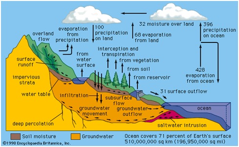
Most groundwater originates as meteoric water from precipitation in the form of rain or snow. If it is not lost by evaporation, transpiration or to stream runoff, water from these sources may infiltrate into the ground.
What are the Different Types of Underground Water Sources?
- Infiltration Galleries.
- Infiltration Wells.
- Springs. (Gravity Springs, Surface Springs, Artesian Springs.)
- Wells.
GROUND-WATER MOVEMENT
The ground-water system as a whole is actually a three-dimensional flow field; therefore, it is important to understand how the vertical components of ground-water movement affect the interaction of ground water and surface water. A vertical section of a flow field indicates how potential energy is distributed beneath the water table in the ground-water system and how the energy distribution can be used to determine vertical components of flow near a surface-water body. The term hydraulic head, which is the sum of elevation and water pressure divided by the weight density of water, is used to describe potential energy in ground-water flow systems. A generalized vertical section of subsurface water flow. Water that infiltrates at land surface moves vertically downward to the water table to become ground water. The ground water then moves both vertically and laterally within the ground-water system. Movement is downward and lateral,mostly lateral in the center, and lateral and upward.
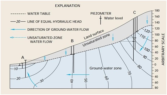
Flow fields such as these can be mapped in a process similar to preparing water-table maps, except that vertically distributed piezometers need to be used instead of water-table wells. A piezometer is a well that has a very short screen so the water level represents hydraulic head in only a very small part of the ground-water system. A group of piezometers completed at different depths at the same location is referred to as a piezometer nest. By starting at a water-table contour, and using the water-level data from the piezometer nests, lines of equal hydraulic head can be drawn. Similar to drawing flow direction on water-table maps, flow lines can be drawn approximately perpendicular to these lines of equal hydraulic head.
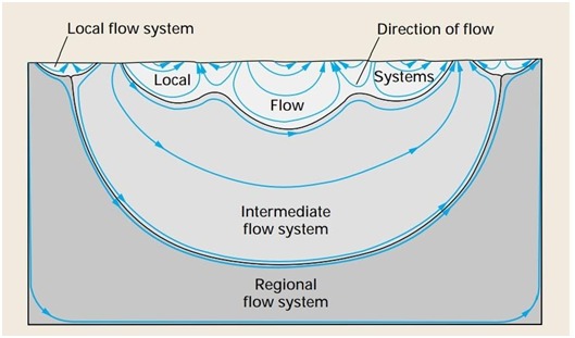
Actual flow fields generally are much more complex. For example, flow systems of different sizes and depths can be present, and they can overlie one another. In a local flow system, water that recharges at a water-table high discharges to an adjacent lowland. Local flow systems are the most dynamic and the shallowest flow systems; therefore, they have the greatest interchange with surface water. Local flow systems can be underlain by intermediate and regional flow systems. Water in deeper flow systems Have longer flow paths and longer contact time with subsurface materials; therefore, the water generally contains more dissolved chemicals. Nevertheless, these deeper flow systems also eventually discharge to surface water, and they can have a great effect on the chemical characteristics of the receiving surface water.
Surface Water:
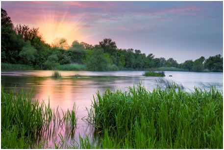
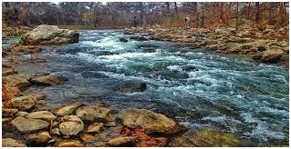
Surface water is water located on top of the Earth’s surface such as rivers, creeks, and wetlands. This may also be referred to as blue water. The vast majority is produced by precipitation and water runoff from nearby areas. As the climate warms in the spring, snowmelt runs off towards nearby streams and rivers contributing towards a large portion of our drinking water. Levels of surface water lessen as a result of evaporation as well as water moving into the ground becoming ground-water. Alongside being used for drinking water, surface water is also used for irrigation, wastewater treatment, livestock, industrial uses, hydropower, and recreation.[1] It is recorded by the Environmental Protection Agency (EPA), that approximately 68 percent of water provided to communities comes from surface water. Surface water is considered freshwater when it contains less than 1,000 milligrams per liter (mg/L) of dissolved solids.
There are three major types of surface water. Permanent (perennial) surface waters are present year round. This includes rivers, swamps, and lakes. Semi-permanent (ephemeral) surface water refers to bodies of water that are only present at certain times of the year including areas such as creeks, lagoons, and waterholes. Man made surface water is water that can be continued by infrastructure that humans have assembled. This would be lakes, dams, and artificial swamps. The surface water held by dams can be used for renewable energy in the form of hydropower. Hydropower is the forcing of surface water sourced from rivers and streams to produce energy.
Surface waters could be regarded as including all inland waters permanently or intermittently occurring on the Earth surface in either liquid (rivers, temporary streams, lakes, reservoirs, bogs) or solid (glaciers, snow cover) condition but this article does not attempt to cover the latter. All types of liquid surface waters are considered—rivers, reservoirs, lakes, bogs. The basic terms used to describe these water bodies are defined. Their types and classifications are given, and data are presented on the largest rivers, lakes and reservoirs.
Surface waters play a very important role in economics and the functioning of ecosystems. According to their topographic and morphological peculiarities, and hydrological regime, lakes can be subdivided in three different ways:
- into lowland, foothill and mountain rivers, depending on relief;
- into large, medium and small, depending on river size;
- into snow-fed, rain-fed, glacier-fed and groundwater-fed, depending on sources of supply.
Lakes can be also divided according to their size, the origin of their depressions, their water regime, degree of river channel stability, water exchange character, water balance structure, temperature regime, dissolved load, etc. Data on the largest rivers and reservoirs are cited.
About 3.5 million km2 of the Earth are covered with wetlands and mires, or peatlands. The article provides a general classification of peatland landscapes and microlandscapes, based on ecological characteristics and vegetation.
Surface water and groundwater are reservoirs that can feed into each other. While surface water can seep underground to become groundwater, groundwater can resurface on land to replenish surface water. Springs are formed in these locations.
There are three types of surface water: perennial, ephemeral, and man-made. Perennial, or permanent, surface water persists throughout the year and is replenished with groundwater when there is little precipitation. Ephemeral, or semi-permanent, surface water exists for only part of the year. Ephemeral surface water includes small creeks, lagoons, and water holes. Man-made surface water is found in artificial structures, such as dams and constructed wetlands.
Since surface water is more easily accessible than groundwater, it is relied on for many human uses. It is an important source of drinking water and is used for the irrigation of farmland. In 2015, almost 80 percent of all water used in the United States came from surface water. Wetlands with surface water are also important habitats for aquatic plants and wildlife.
The planet’s surface water can be monitored using both surface measurements and satellite imagery. The flow rates of streams are measured by calculating the discharge—the amount of water moving down the stream per unit of time—at multiple points along the stream. Monitoring the flow rate of streams is important as it helps determine the impact of human activities and climate change on the availability of surface water. Keeping track of vegetation around bodies of surface water is also important. The removal of vegetation, either through natural means such as fires, or through deforestation, can have a negative impact on surface water. Loss of vegetation can lead to increased surface runoff and erosion, which in turn can increase the risk of flooding.
These fresh surface waters sustain ecological systems and provide habitat for many plant and animal species. They also support a myriad of human uses, including drinking water, irrigation, wastewater treatment, livestock, industrial uses, hydropower, and recreation.
Rainwater; a fundamental source of Water:
Rain is the original water on the Planet. The irony is rain water that is falling on our habitats is draining out to sewers or ocean. Rainwater that is considered as the best sources of water, is neglected by most of our communities, developers, industries, institutions. The water that actually feeds major sources of water; i.e. Ground water and Surface water is left out. A simple step to stop flowing of this fresh source of water and retaining for reuse or recharging our groundwater will prevent depleting of Groundwater and drying of Surface water. Once this is implemented as a primary duty, not only will it reduce electricity bills but also will make us water secure. This is the remedy of water crisis. Let’s harvest rain.
Do the Earth a favor ….!
Be a water saver …. !!
VardhmanEnvirotech,
India’s Passionate Rainwater Company